
Weather Observation Codes are used to determine the state of the sea and weather for the purpose of recording it consistently in log books and over radio. They provide an abbreviated method of describing conditions from visual observations. This page describes 4 different scales to denote wind, sea disturbance, visibility and state of weather.
Beaufort Wind Scale
The Beaufort Scale is an empirical measure that relates wind speed to observed conditions at sea or on land. Its full name is the Beaufort wind force scale. The scale was devised in 1805 by the Irish hydrographer Francis Beaufort, a Royal Navy officer while serving on HMS Woolwich. The scale that carries Beaufort’s name had a long and complex evolution from the previous work of others to when Beaufort was a Hydrographer of the Navy in the 1830s when it was adopted officially and first used during the voyage of HMS Beagle. More on Wikipedia
In the 18th century, naval officers made regular weather observations, but there was no standard scale and so they could be very subjective. Beaufort succeeded in standardising a scale through visual observations.
Below is a table showing the Beaufort Scale with speeds in knots and wave heights in metres.
Code |
Description |
Wind Speed (Kts) |
Wave Height (m) |
Sea Conditions |
|---|---|---|---|---|
0 |
Calm |
0kts |
0m |
Like a mirror |
1 |
Light Air |
1-3kts |
0 – 0.3m |
Ripples with appearance of scales are formed, without foam crests |
2 |
Light Breeze |
4-6kts |
0.3 – 0.6m |
Small wavelets still short but more pronounced; crests have a glassy appearance but do not break |
3 |
Gentle Breeze |
7-10kts |
0.6 – 1.2m |
Large wavelets, crest begin to break; |
4 |
Moderate Breeze |
11-15kts |
1 – 2m |
Small waves becoming longer and fairly frequent white horses |
5 |
Fresh Breeze |
16 – 20kts |
2 – 3m |
Moderate waves taking a more pronounced long form. Many white horses are formed. Chance of some spray. |
6 |
Strong Breeze |
21-26kts |
3-4m |
Large waves begin to form. The white foam crests are more extensive everywhere. Probably some spray. |
7 |
Near Gale |
27-33kts |
4 – 5.5m |
Sea heaps up and white foam from breaking waves begins to be blown in streaks along the direction of the wind. Spindrift begins to be seen. |
8 |
Gale |
34-40kts |
5.5 – 7m |
Moderately high waves of greater length. Edges of crests break into spindrift. Foam is blown in well-marked streaks along the direction of the wind. |
9 |
Strong Gale |
41-47kts |
7 – 10m |
High waves. Dense streaks of foam along the direction of the wind. Sea begins to roll. Spray affects visibility. |
10 |
Storm |
48-55kts |
10 – 12.5m |
Very high waves with long overhanging crests. Resulting foam in great patches is blown in dense white streaks along the direction of the wind. On the whole the surface of the sea takes on a white appearance. Rolling of the sea becomes heavy. Visibility affected. |
11 |
Violent Storm |
56-65kts |
12.5 – 14m |
Exceptionally high waves. Small- and medium-sized ships might be for a long time lost to view behind the waves. Sea is covered with long white patches of foam. Everywhere the edges of the wave crests are blown into foam. Visibility affected. |
12 |
Hurricane |
> 65kts |
>14m |
The air is filled with foam and spray. Sea is completely white with driving spray. Visibility very seriously affected. |
State of Weather Codes
Beaufort Notation to indicate the State of the Weather. In this scale the weather designations could be combined, and reported, for example, as “s.c.” for snow and detached cloud or “g.r.q.” for dark, rain and squally.
Weather |
Code |
|---|---|
Active |
a |
Blue Sky (<25% clouded) |
b |
Cloudy (>75% clouded) |
c |
Partly Cloudy (Combining b and c) * |
bc |
Drizzling Rain |
d |
Fog |
f |
Dark and gloomy |
g |
Hail |
h |
Lightning |
l |
Overcast |
o |
Passing Showers |
p |
Squally |
q |
Rain |
r |
Snow |
s |
Thunder |
t |
Ugly (Threatening) |
u |
Visibility (Unusual Transparency) |
v |
To denote Partly Cloudy, combine two codes Blue Sky (b) and Cloudy (c) to: bc
Visibility Codes
The international standards for describing visibility in marine forecasts in metric ranges are as follows:
Code |
Description |
Distance of Vision |
|---|---|---|
0 |
Dense Fog |
< 50m |
1 |
Thick Fog |
50 – 200m |
2 |
Fog |
200 – 500m |
3 |
Moderate Fog |
500 – 1000m |
4 |
Mist or Thin Fog |
1000 – 2000m |
5 |
Poor Visibility |
2 – 4 km |
6 |
Moderate Visibility |
4 – 10km |
7 |
Good Visibility |
10 – 20km |
8 |
Very Good Visibility |
20 – 50km |
9 |
Exceptional Visibility |
> 50km |
Sea State Disturbance Codes
The Sea Disturbance Code refers to the World Meteorological Organization (WMO) sea state code, a system used to describe the state of the sea surface based on wave height and period. It is the vertical distance between the crest and the trough of a wave.
The code provides a standardised way to communicate sea conditions between mariners and weather forecaster. WMO Sea State Codes and Descriptions:
Code |
Description |
Height of Wave (Crest to Trough) |
|---|---|---|
0 |
Calm – Glassy |
0m |
1 |
Calm – Rippled |
0 – 0.1m |
2 |
Smooth – Wavelets |
0.1 – 0.5m |
3 |
Slight |
0.5 – 1.25m |
4 |
Moderate |
1.25 – 2.5m |
5 |
Rough |
2.5 – 4m |
6 |
Very Rough |
4 – 6m |
7 |
High |
6 – 9m |
8 |
Very High |
9 – 14m |
9 |
Phenomenal |
> 14m |
Wind Direction Short Codes
Wind direction is generally reported by the direction from which the wind originates. For example, a north or northerly wind blows from the north to the south. The exceptions are onshore winds (blowing onto the shore from the water) and offshore winds (blowing off the shore to the water). Wind direction is usually reported in cardinal (or compass) direction, or in degrees. More on Wikipedia
Wind direction can be described using short codes or abbreviations. Common short codes include: N (North), E (East), S (South), W (West), NE (Northeast), SE (Southeast), SW (Southwest), and NW (Northwest). These codes are often used on weather maps and in weather reports. Following is a break down of the most common direction and winds:
Cardinal Directions/Principal Winds: N, E, S, W represent North, East, South, and West, respectively.
Intercardinal Directions/Half Winds: NE, SE, SW, and NW represent Northeast, Southeast, Southwest, and Northwest, respectively.
Secondary Intercardinal Directions/Quarter Winds: The Intercardinal Directions can be divided even further: north-northeast (NNE), east-northeast (ENE), east-southeast (ESE), south-southeast (SSE), south-southwest (SSW), west-southwest (WSW), west-northwest (WNW), north-northwest (NNW).
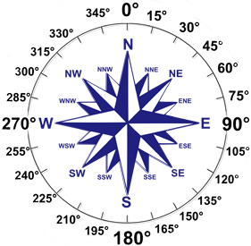
Direction Short Code |
Direction Description |
Degrees |
|---|---|---|
N |
North Wind |
0° / 360° |
NNE |
North North East |
22.5° |
NE |
North East |
45° |
ENE |
East North East |
67.5° |
E |
East Wind |
90° |
ESE |
East South East |
112.5° |
SE |
South East Wind |
135° |
SSE |
South South East |
157.5° |
S |
South Wind |
180° |
SSW |
South South West |
202.5° |
SW |
South West Wind |
225° |
WSW |
West South West |
247.5° |
W |
West Wind |
270° |
WNW |
West North West |
292.5° |
NW |
North West Wind |
315° |
NNW |
North North West |
337.5° |
Exercises
As Deck Officer on M/S Mary Jane, you are responsible for keeping the ships log updated every hour with weather, sea and visibility conditions. You also need to record other information about the voyage such as vessel speed, heading and distance travelled in nautical miles. Use the description of visualisations in each tab exercise together with readings from your Wheelhouse instruments.
A couple of notes on the log columns:
- Log Time: The 24-hour clock is used to record time entries, particularly for events like departure, arrival, and radio communications. It ensures consistent timekeeping across different locations and simplifies calculations, especially when dealing with time zones and international regulations. For example 06:00 is equivalent of 6am and 13:00 is the same as 1pm.
- Compass Heading: The vessel compass is magnetic. It works by using the Earth’s magnetic field to determine direction. Specifically, it contains a magnetized needle that aligns itself with the Earth’s magnetic north. This is in contrast to GPS devices which typically display headings and bearings in True North. Logs may vary on vessels with some using True or Magnetic. Some additionally record the compass error (Deviation) in the log. M/S Mary Jane records Magnetic only so make sure you use the compass value when recording heading in below exercises.
- Log Distance: This is the distance travelled in nautical miles (nm) since your last log recording. Use the time difference between previous log entry to current time in combination with vessel speed. Vessel speed or Speed Over Ground is meassured in Knots (kts) which nautical miles travelled per hour. If your vessel cruising at 12 kts for an hour, you have travelled 12nm.
- Total Distance: Is the accumulated distance travelled since first log entry.